To understand the complex nature of disputes over the Paracel and Spratly Islands, a comprehensive integration of the legal and the political perspectives is required. The legal perspective allows us to determine whether arguments of the claimants are valid and whether they are actually supported by historical facts. This essay reviews and analyses the arguments of the claimants from the perspective of international law and argues for Viet Nam’s position.
Những tấm bản đồ, hình ảnh sau đây là những bằng chứng không thể chối cãi về chủ quyền của Việt Nam với hai quần đảo Hoàng Sa và Trường Sa.
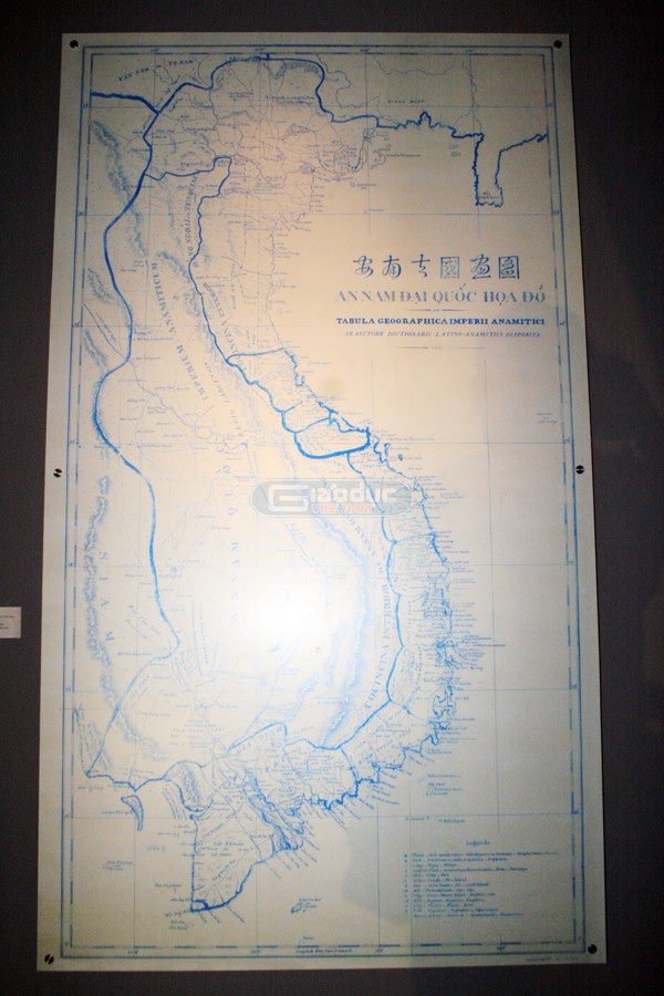
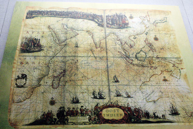
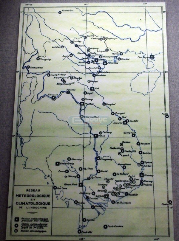
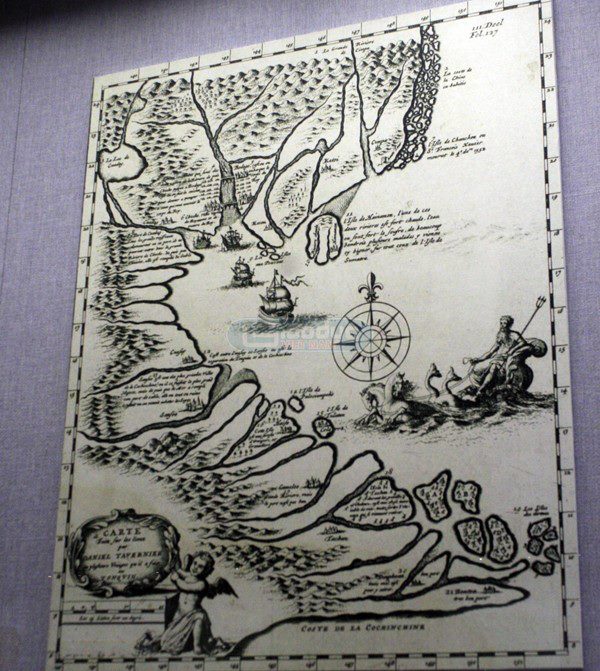
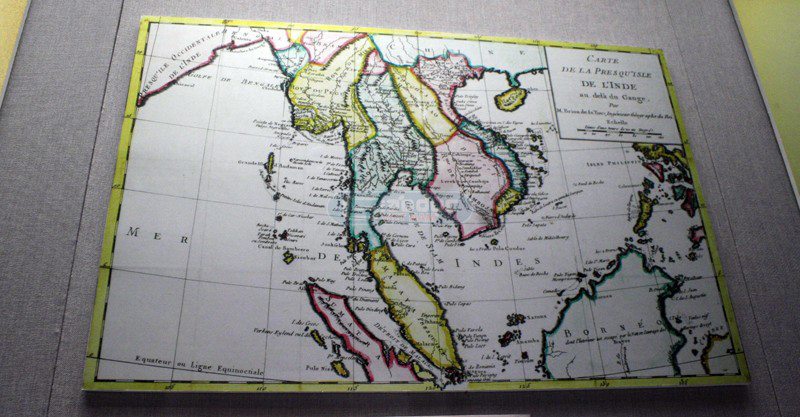
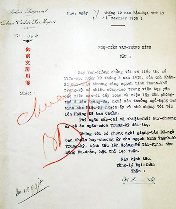
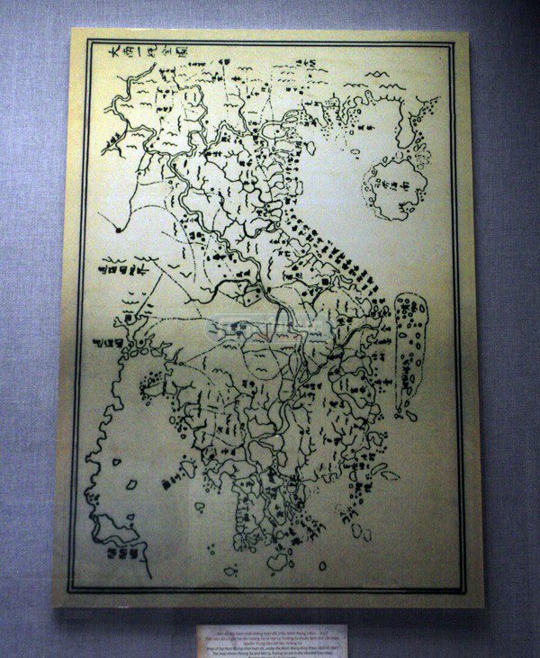
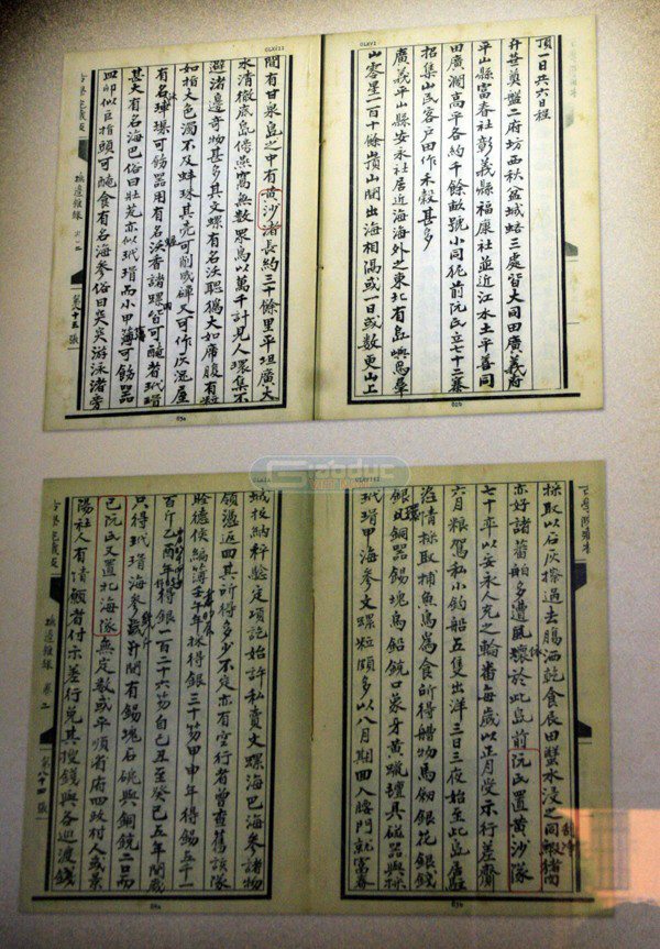
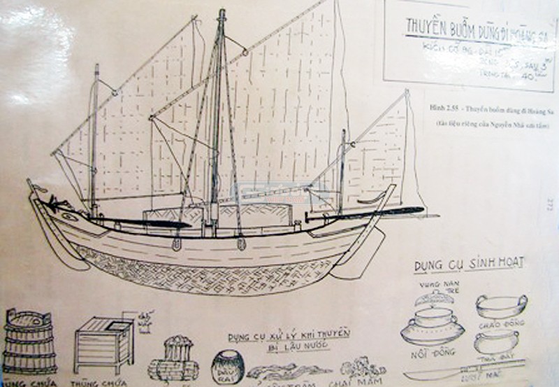
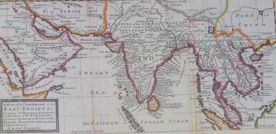
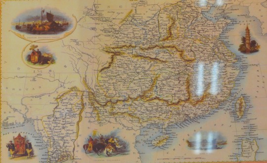
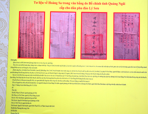
Bản đồ “An Nam Đại Quốc Họa Đồ” do giám mục Taberd (Pháp) lập và xuất bản năm 1838 đã vẽ rất chính xác về tọa độ Paracel hay Hoàng Sa của Việt Nam.Bản đồ Châu Á thế kỷ XVII vẽ một phần của “Paracel” hay “bãi cát vàng” khu vực quần đảo Hoàng Sa của Việt Nam hiện nay.Bản đồ các đài khí tượng Đông Dương, 1940. Đài Pattle (Hoàng Sa) và đài ở Ita Aba (Trường Sa) là hai đài khí tượng cấp quan trọng nhất của Việt Nam.Bản đồ Tonquin (Miền Bắc Việt Nam), 1682 do Daniel Tavernier vẽ trong những năm 1640 khi ông làm thư ký cho Công ty Đông Ấn Hà Lan ở Đàng Ngoài.Bản đổ vùng Viễn Đông, Brion de la Tour, 1774. Trên bản đồ vẽ quần đảo Paracel (Hoàng Sa) thuộc lãnh thổ Đàng Trong, Đại Việt.Một tờ châu bản triều Nguyễn, Bảo Đại năm thứ 13 (1939) liên quan đến đảo Hoàng Sa“Đại Nam nhất thống toàn đồ” đầu thế kỷ XIX. Đây là bản đồ nước Việt Nam thời nhà Nguyễn vẽ khoảng năm 1834, trên bản đồ có ghi 2 tên Hoàng Sa và vạn lý Trường Sa thuộc lãnh thổ Việt Nam. The Paracel and Spratly Islands have been subject to the sovereignty of Viet Nam by reason of terra nullius (land not belonging to any sovereign State) effectively occupied by Viet Nam since the 16th century4 trang Phủ Biên tạp lục, Lê Quý Đôn, 1776 , chép về việc thành lập và tổ chức hoạt động của Hải đội Hoàng Sa, Hải đội Bắc Hải. Viet Nam uses official documents from the 17th century to support these arguments. These include Đại Nam thực lục tiền biên (1600–1775) (大南實錄前編, The Early Chapter of The Chronicles of Đại Nam [Đại Nam is an ancient name of Vietnam]), Toản tập Thiên Nam tứ chí lộ đồ thư (1630–1653) (纂集天南四至路图書, The Collection of the South’s Road Map), Phủ biên tạp lục (1776) (撫邊雜錄, Miscellany on the Pacification at the Frontier), Đại Nam thực lục chính biên (1848) (大南實錄正編, The Main Chapter of The Chronicles of Đại Nam), Đại Nam nhất thống chí–the combinatorial record for geography and history of Đại Nam (1865–1882) (大南ー統誌, The Record of The Unified Đại Nam), Hoàng Việt dư địa chí (1833) (皇越輿地誌, Geography of The Viet Empire), Việt sử thông giám cương mục khảo lược (1876) (越史通鑑綱目考略, Outline of The Chronicles of The Viet History), official documents of the Nguyễn Dynasty on petitions and imperial decrees, and many maps and documents made by other countries at that time2. Jaseniew Vladimir and Stephanow Evginii, in their 1982 book entitled “The Chinese Frontiers: From Traditional Expansionism to Present Hegemonism”, listed the activities of the Vietnamese States in continuously exercising their sovereignty over the Paracel and Spratly Islands, and emphasized that “feudal States of Viet Nam had for long annexed archipelagos such as the Paracels and Spratlys into their State’s territory”3.Thuyền buồm của Hải đội Hoàng Sa thời nhà Nguyễn Thuyền buồm của Hải đội Hoàng Sa thời nhà Nguyễn sau khi được phục dựngThe States of Viet Nam knew of the Paracel and Spratly Islands, grouped them together, named them as “Đại Trường Sa” (Hán-Nôm: 大長沙; English: Grand Long Sand), “Hoàng Sa” (黃沙, Yellow Sand), or “Vạn Lý Trường Sa” (萬里長沙, Ten-Thousand-Mile Long Sand), and considered them as part of Viet Nam’s territory.Throughout more than three hundred years, from the 16th to the 19th centuries, the States of Viet Nam had continuously exercised their sovereignty at least over the Paracel Islands by frequently sending the Flotillas of Hoàng Sa and Bắc Hải to the archipelago, which would stay there for several months every year for surveying and exploiting resources in a systematic manner. Personnel from these flotillas collected goods from wrecked ships, built temples, planted trees to symbolize the State’s sovereignty, collected taxes, and provided assistance to foreign ships in danger. These activities of the Vietnamese States were totally free from any opposition or disputes from other countries, including China, and contained both the corpus and animus elements of an actual possession.The sovereignty stele built on Hoang Sa in March 1938 by Vietnamese guards.The birth certificate of Mrs Mai Kim Quy, the daughter of Mr. Mai Xuan Tap, a meteorological staff on Hoang Sa, granted by the French government in 1940.Vietnamese soldiers dug wells for fresh water on Hoang Sa in 1938. In addition to maps, precious materials, the organizers also display snails, corals and sand collected from Hoang Sa and Truong Sa by fishermen.The valuable document about Hoang Sa which was donated to the Ministry of Foreign Affairs in April 2009 by the Dang family on Ly Son Island, Quang Ngai province. The document was preserved by the six generations. This is the mission order by Quang Ngai’s feudal authorities sending three boats with 24 soldiers to guard Hoang Sa in 1834. The order consists of four pages.This ancient book clearly wrote that King Minh Mang assigned Mr. Pham Huu Nhat to take his soldiers to Hoang Sa to build sovereignty landmarks in 1836.
The exhibition of historical and legal evidences asserting that Hoang Sa (Paracel Islands) and Truong Sa (Spratly Islands) belong to Vietnam is held in the central province of Phu Yen from March 28 to April 3, on the occasion of Vietnam Seafood Festival 2014.